This
short article was written by M. George
and
appeared in the April 1981 edition of the Breachwood Times
Although Breachwood Green is not mentioned in the Domesday Book (1086) there is no doubt that people were living here at that time. Many of our local place names indicate Saxon settlement of the area in the 8th and 9th centuries. The earliest surviving written records show a pattern of settlement, much as today, of scattered hamlets and isolated farmsteads and cottages. There are many surviving documents (charters) from the 12th century onwards, now held in the British Museum, which give glimpses of what the local area was like. From these it is possible to recreate a picture of the village in the late 13th and early 14th centuries. It was in this period that the village began to take on its present shape.
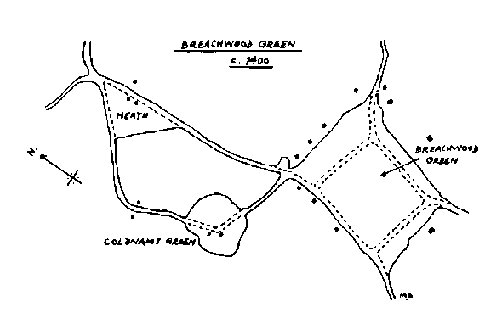
By the late 1200's there were many scattered homesteads in the parish, each with its own garden and small closes. Large common arable fields lay nearby, where the cottagers grew their crops in open strips of land. Settlements developed on and around pieces of waste or common ground. In this area, a number of houses had been built around a piece of common woodland (owned by the lord of the manor but offering commoners' rights of grazing and firewood) called "le Brach Wode" in a charter of 1287.
What is now the 'green' was then a larger area of open woodland with mature trees. On one side (Pasture Lane) was another wood (Greathouse); on the opposite side (Chapel Road) was a farmstead. There were other farmsteads and cottages nearby. In 1333 the Lord Walter de Neville, felled the 236 large trees in the wood and "le Brach Wode" became an open common or 'green' on which the surrounding tenants grazed their animals. Although the name 'Brachwoddgrene' does not appear in documents until 1493, the village green was well established before 1400. Not quite as we see it today in the Recreation Ground however, because the original Brach Wood was larger. Until an Act of Parliament enclosed the remaining commons and wastes of the parish in 1802 the green was bounded by Chapel Road, Bailey's Lane along a line closer to Bailey's farmhouse, Pasture Lane along a line some fifty yards closer to Greathouse Wood, and by the line of the footpath running from Orchard Way to Crossways. Both sides of present day Oxford Road, the Meadows, Pasture Lane and the buildings on the chapel side of Chapel Road date from after the enclosure and were built on parts of the former green. The oldest village buildings are set back on the line that marked the edge of the medieval Brach Wood.
Breachwood Green today includes what in medieval times were separate hamlets at the Heath (another area of common waste land) and Brownings/Colemans Green. People living at these places are mentioned in early 14th century charters. Darley is mentioned in a document of 1189. It was somewhere between Breachwood Green and Darley that, in 1912, workmen discovered a pagan Saxon burial of about 560 A.D. Does anyone recall their parents or grandparents talking about that discovery 70 years ago? The precise location is not recorded in the archaeological records, which is a pity because that Saxon woman, with her pagan grave goods, is our earliest recorded inhabitant.